
Author of Be Ready for Anything and Build a Better Pantry on a Budget online course
I’ve always had a pretty decent sense of direction in urban environments. When I was in Croatia, others commented on this, so recently I have been thinking about how it is that I’m able to find my way back to my home base without using navigational tools like maps.
While, of course, I have a map and a compass, if there was an event that occurred which made me want to get home in a hurry, I’d rather know my way around without it instead of being forced to stop at every intersection and find the right way to go.
This proficiency isn’t just for city dwellers or travelers. Being able to quickly navigate through an urban environment is a very important skill. You never know when the S is going to hit the Fan. You might be at a doctor’s appointment in the city, shopping, or on a business trip. If the emergency is big enough, you may not be able to rely on Google maps or other navigational software to get yourself out of the area.
This is the way I orient myself quickly when I arrive in a new city.
Take a walk.
First things first, even if you have a vehicle to drive or plan to take public transit, you should take a walk. Since walking is slower, it’s easier to notice those little details that pass by in a blur when you’re in a car.
This morning, after arriving in a new city, I took an orientation walk to learn about my immediate neighborhood. To make this walk even more effective, I used the time to stock up on supplies for the next few days. I got food, snacks, drinks, etc.
Subscribe to our newsletter
Trying to figure out how to stock up while prices keep climbing? We can help with our free guide and newsletter!
I like to walk a minimum of 3 city blocks around the perimeter neighborhood of my apartment. I find the busier streets which are generally a good source of food and supplies. While I’m walking I take note of any place that would have useful supplies in the event of an emergency, like camping stores or hardware stores.
Remember landmarks.
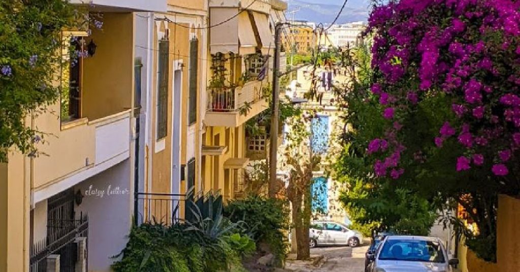
Here in Greece, street names aren’t especially helpful to me because I don’t read Greek – they use a different alphabet. I find that even when I attempt to memorize the letters, it doesn’t make as much of an impression on me as landmarks do.
When I say “remember landmarks” that doesn’t necessarily mean that I’m remembering big touristy things like the Acropolis.
For your own purposes, a landmark can be anything that catches your eye. For example, today I found a door in a beautiful shade of lavender where I turn to get back to my house. Sometimes it might be a shop that has some interesting architectural features. It could be a restaurant that looks like it would have tasty food. Maybe it’s a large flowering plant or unusual balcony. You get the idea – find things that catch your eye.
A big one here in the city I’m currently visiting (Thessaloniki, Greece) is the sea. This is a large, unmoving landmark that is in front of my apartment.
Where are the landmarks in correlation to your home base?
Next – and this is the most important thing – where are all your landmarks in correlation to your home base?
This city is basically a mountain that leads down to the sea. So if I started out walking downhill, any time I face the sea, my apartment will be behind me. If I’ve walked uphill, when I turn to face the sea, my apartment is that way. A large body of water that you can see from multiple vantage points is a great landmark for orientation.
But not all cities are by the sea or a river, so you’ll need other landmarks too.
One block down the hill from my apartment is an extremely large church from the Byzantine era. That’s tough to miss and can be seen from a lot of different locations because of its size. I know that if I see that church, which is built into a hill, I simply need to walk uphill and I’m on my street. I also know that my apartment building is to the left when I get to the back of the church.
Coming from a different direction, I should turn right when I’m facing the charming lavender door I mentioned earlier. That’s one of the landmarks I use to find my street. I also found landmarks at the cross streets that my apartment lies between.
Each day, build your mental map out a little bit further.
As you explore the new area you’re visiting, each day you should venture a bit further. Find new landmarks further away and then think about where they are in relation to your home base. For example, if I go to visit a castle tourist attraction that is about a 20-minute walk to the left of my apartment, then toward the sea, it’s pretty simple to navigate my way home.
Another great way to work on your navigation skills while traveling is to use something like Google maps to get you to where you’re going, then use your landmarks to get you back home.
By the time you’ve been in an area for a week or so, you should have a mental image of your home base that is like a sun with rays coming out of it. Your apartment is the center, and each ray leads to a landmark. From each landmark, you’ll be able to make your way home.
You’ll get lost sometimes.
Obviously, this is easier if the city you’re visiting is laid out in a grid. If it’s not, you’ll need additional landmarks to remind you where to turn.
I like to challenge myself so recently when I was in Athens, (which is not a grid at all I might add) I decided to try and find my way back from about 4 miles from home. I purposely took a different road first because I didn’t want to simply backtrack. I walked for about 2 hours and was about to give up and call an Uber for rescue when I saw a movie theater I had noticed a few days previously because it showed only old movies and charged 10 Euros for three movies.
As soon as I saw that, I immediately recognized where I was and was able to walk home in a fairly short order.
You can’t be afraid to get lost when you’re doing this. Just be sure you have a few safety nets in case you get really, really lost. (No, you don’t have to add any of these apps to your phone – but I’ve found them to be useful tools, personally.)
- Have navigational supplies with you at all times in your everyday carry kit.
- If you feel like you’ve walked into a dangerous neighborhood, you probably have. Turn around and go back the way you came. Pay attention to those “bad feelings” – you’re usually experiencing them for a reason.
- Put the Uber app on your phone. Not all cities have Uber, but if they do, the driver will locate you via the GPS on your phone.
- Have a navigational app on your phone like Google Maps or Garmin. Program in the address of your local home base.
- Always carry a paper map. The first thing I do in a new city is to grab a map. Then I mark where I’m staying on the map with a dot.
- If you don’t know how to read a compass and use it with a map, learn. I thought I knew how to use one but when I went to Selco’s Urban Survival Course in Croatia last year, Toby, the co-instructor, had to give me a refresher course.
Learning to navigate is a very important skill and I strongly recommend it to everyone. Even if you are a person who thinks they have a terrible sense of direction, try using landmarks instead of North, South, East, and West and see if this makes things easier for you.
Work on your navigational skills.
You don’t have to head to another country to find unfamiliar territory. Just head to the next town over and park your car in a new neighborhood. (This is home base.) Then start exploring.
Make sure you don’t have anything to do the day you decide to go plunk yourself down and get lost because a time deadline can make this very stressful.
However, when you have plenty of time, not only is this an educational exercise, but it’s a whole lot of fun. I have seen all sorts of things that are off-the-beaten-path during my navigational excursions. And I’ve also found the more I do this, the faster I become oriented in new places.
What are your best tips for navigating through the city? Please share them in the comments below.


14 Responses
Does not have to only apply to urban settings.
Around here, make a left at the big weathered oak tree by the brook.
About 100yrds past the old stone wall, take the game trail on the left.
If the sun is in your face at 0900, that is East, West is to your back, South to your right, and North to your left.
And forget about moss growing on the north side of trees–or anything else, for that matter. In my city, it grows on the west side of concrete pads…
And, your pace count.
Go to a local high school with a football field. Starting at the one goal line, feet together, step off with the left foot and count, out loud, “1.” Every time your left foot comes down (at your regular, natural pace) count, till you reach the far goal line, 100 yards.
Do that 3 or 4 times and you will get a average.
That is your pace count.
Granted that is on level, ground. But you can and will have to adjust for hilly or rough terrain. That applies to either hilly urban environments (IIRC Daisy was in the Balkans and encountered a lot of hills or stairs in a urban environment, that would have to be taken into account, only experience would give you a real world account of your pace count), or in woodland environments.
To keep your count, in the golf world, they have these count beads on a length of cord to keep track of how many shots they have taken.
They work for land navigation too.
Two cents regarding Count Pace exercise, try it with your eyes closed and then notice if you have drifted off to the left or right due to one leg being stronger, the dominant leg, similar to a dominant eye. The weaker leg acts like a pivot to the stronger leg so you will curve inward opposite to the stronger leg. One reason on patrol a ‘left-foot’ person alternates down the line with a ‘right-foot’ person to keep the line going straight forward, more or less.
Some disasters can make navigating by landmarks difficult. Earthquakes can and will knock down buildings, as can volcanoes and tornadoes. Large fires can burn down landmarks and along with volcanoes can change the color of things with ash and soot. I think it was the Haiti earthquake that caused so much damage that even the locals couldn’t find their way around. Like Daisy said, write down the GPS coordinates of your home base and carry maps with home base clearly marked.
Having found myself in a number of larger cities, (Boston, Miami, LA, San Jose for a few) I developed a strategy of looking closely at my lodging for its safety or lack thereof. One memorable national motel had so much insecticide in the stair wells that you almost couldn’t make it out of them, and it was needed. My clothing never made it to the house, I went to a laundromat on the way home. After that, I would drive around the neighborhoods finding where the grocery, hardware stores were. Movie houses? what restaurants are there and is there a coffee house where I can sit and watch people? Ah yes, the people. Are the people on the street wearing gang tats?, Do they appear worried? Are there odd little enclaves that are are more run down, cars on cinder blocks, or the people are just different in some way. I enjoyed it all. By the way, wear sunglasses so the locals don’t realize you are watching.
What you are alluding to is “terrain association” or “orienteering.”
Know the basics of how to move around without a map. That doesn’t mean don’t study one, it just means you have gathered enough knowledge of the area to get “home” in a pinch without GPS or map.
I’ve subtly taught the kids to terrain associate since they were around three. They were getting grandpa lost on purpose by age 5. The only one who was un-amused was grandpa.
Pointing out simple things like “the house with the red roof”, or the house with the green garage doors was easy to remember, and helped create the default thought process of seeing what is around them without even slowing down to point it out.
Regardless of your ability to remember “the house with the red roof”, one should always do what I tell the kids is “conduct your map reconnaissance”. Before you travel, use a website to find where your hotel is, and identify the major roads/streets nearby. I always tell the kids “GPS is for the last 100 yards.” I’ve already conducted research on the route I intend to take to a location, and only use the GPS to assist with the last 100 yards so I don’t miss the turn to the dr office or whatnot.
Learning the street address system is useful as well. That little sign above “Broadway Blvd” that says 3700 means you are either entering or departing the 3700 block of broadway. All the buildings there will have an an address of 37xx Broadway Blvd. I’ve used that to help the kids understand how to find a place they have never been by the number system. Once we are on the right street, they start counting down/up the streets until we are coming up on the address we want. Odd numbered addresses are on one side, even numbered addresses are on the the other. Its your job to figure out which by finding a business’ street address (usually right above the door).
Beware if you are from the Northern Hemisphere and you go to the Southern or vice versa! Your inbuilt compass will trap you and you will confuse North and South! It just won’t feel right. (I’m from Australia and until I worked that out I was hopelessly lost even with a map! I’m good at home and that gave me a false sense of security!) The more developed you homing sense is I found the worse it gets. Most of the advice here will help. So will the button compass and map you always carry when you are far from home.
When we’ve taken our kids to places that my wife and I didn’t know well, a few dollars spent on a “Grey Line” (or similar) bus tour of the major attractions has paid dividends. “Ohh that looked neat I want to go there in a day or so”, versus “mehh, maybe next year”. The bus ride will allow you to get your bearings, spot landmarks, scope out some places that are a moderate walk from your home base. We did this in NYC, Paris, and New Orleans with great success.
Those buses are phenomenal! I’ve used them before too. 🙂
Instead of entering my base address, I use a business address close by. If my cell or gps gets stolen, they will not know where home base is.
Think of a shape for each area of the location I go, it can be a pie shape, a grid, whatever works.
You have to remember your landmark may look different wether it’s day or night, sunny or rainy or snowy.
My dad has always played the following trick on us when we were kids. When we would go visit my uncle, he would pretend he was lost and couldn’t remember the way to go to his brother’s house as soon as we entered the perimeter of that city. He never used the same exit twice to go there as well. We had to rely on our recollection of landmarks at a young age, way before we learned to read!
While traveling I would write down address where staying and information, get a paper map of area, if no paper maps take a picture of map on wall. Remember land marks, take a bus around city and decide what I wanted to visit. Always take lots of pictures and time it takes to one point to the next. Always ask where the cruise ships dock, train stations are, and bus stations and stops are. Check travel agents in the area. Keep bus tickets for information, because the next person may not understand where you want to go again. Point a lot if they don’t speak the language. Good Luck !!!
I WILL NOT KNOWINGLY HAVE A MICROCHIP PUT IN ME, I WILL GLADLY DIE FIRST, IF GOD HAD WANTED A MICROCHIP IN ME, HE WOULD HAVE PUT IT THERE, SO THANKS, BUT NO THANKS TO THE MICROCHIP.
I not only have the local map downloaded on my phone, but I also have the topo map downloaded for my area………. I live pretty rural. I did this so I could find water , if need be.