
Update: Dorian is now a Category 2 hurricane and is expected to strengthen (possibly to a Category 4) by the time it reaches the southeastern coast of the US this weekend or early next week.
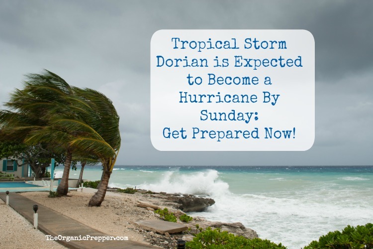
If you live in Florida, Georgia, or the Carolinas, you have (hopefully) heard by now that a big storm is heading your way.
Currently a tropical storm, Dorian is expected to strengthen to a Category 2 hurricane when it reaches the eastern coast of Florida late Sunday night or early Monday morning.
This morning, The Weather Channel issued a warning:
Tropical Storm Dorian will strike Puerto Rico and the Virgin Islands Wednesday, the first storm there since 2017’s Hurricane Maria, and is an increasing danger to the Southeast U.S., including Florida, over the Labor Day holiday weekend.
Dorian’s center is less than 100 miles from St. Croix, in the U.S. Virgin Islands, moving northwest at 10 to 15 mph.
Outer rainbands are already pushing through the Virgin Islands, and will soon sweep into Puerto Rico, according to the NWS Doppler radar from San Juan. Heavier rain near the center of Dorian is now heading toward the Virgin Islands. (source)
In an early morning update today, the National Hurricane Center (NHC) warned that “tropical storm conditions are expected in the US and British Virgin Islands and Puerto Rico today, and are possible in portions of the Dominican Republic tonight and Thursday. Hurricane conditions are possible in Puerto Rico and the US Virgin Islands today.”
Warnings and watches are in effect for some areas.
A tropical storm warning is in effect for Puerto Rico, Vieques, Culebra, and the British and U.S. Virgin Islands. That means tropical storm conditions (39-73 mph winds) are expected there within the next 36 hours, according to The Weather Channel.
A hurricane watch is also in effect for those same areas. Hurricane conditions (74 mph or greater winds) are possible there within the next 48 hours.
A tropical storm watch is in effect for parts of the eastern Dominican Republic. Tropical storm conditions are possible there within the next 48 hours.
At 5 a.m. Wednesday, the National Hurricane Center said Dorian’s maximum sustained winds were at 60 miles per hour with gusts as high as 70 miles per hour.
Dorian is expected to intensify as it approaches Florida, but the storm could change course:
For now, Dorian’s center is expected to track to the east of the Turks and Caicos and southeast Bahamas, but that is subject to change.
Dorian is then expected to bend toward the west-northwest by Friday.
Exactly when and how sharp that leftward bend occurs will be critical in determining where Dorian strikes the southeast U.S. (source)
Dorian may reach the southeastern US by early next week.
NHC forecasters said Wednesday morning that “nearly all of the intensity models show Dorian becoming a hurricane in about 2 days, with additional strengthening beyond that time…the threat of tropical storm or hurricane conditions, along with storm surge, in the northwestern Bahamas and along portions of the Florida east coast have increased.”
The hurricane center’s updated track projected that Dorian could be off the coast of Titusville by 2 a.m. Monday, but the cone of uncertainty shows it could also be anywhere from the southeastern tip of South Carolina to the Everglades or west of Florida in the Gulf of Mexico by that time.
If you live in Florida, Georgia, or the Carolinas, be prepared for tropical storm or hurricane conditions and storm surge. If you don’t have a hurricane preparedness plan in place, now is the time to create one. Please keep a close eye on the forecast.
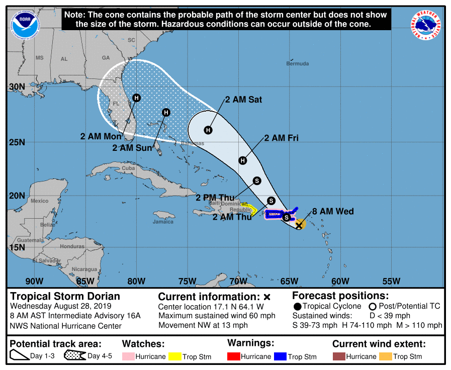
Image source: National Hurricane Center
To view an interactive map, click here: Tropical Storm Dorian
Hurricane Maria ravaged Puerto Rico less than two years ago, and much of its infrastructure, including its water systems, is still recovering. The territory is tragically vulnerable to a hit from another strong storm. The island’s 3.2 million inhabitants still depend on a shaky power grid that has remained prone to outages since it was destroyed by the Category 4 storm. Nearly 30,000 homes still have blue tarps as roofs.
Remember, even if you are outside of the warning cone, preparing is crucial, as this video from NHC explains:
Dorian has the potential to cause life-threatening flash floods. Southern and eastern portions of Puerto Rico and the Virgin Islands could see 4-6 inches of rainfall, with 10 inches possible in isolated areas. The storm is expected to drop 4-8 inches of rain on Florida, with 10 inches in some spots.
Now is the time to prepare.
If you live in an area that may be impacted by Dorian, you should be asking yourself these questions:
- What necessary medical devices do I have and how will I run them without power? (CPAP, Respirators, etc.)
- Do I have enough water and filtration supplies?
- Do I have enough emergency food?
- Do I have a way to cook off the grid? Do I have additional fuel for my cooking method?
- Can I take care of my family medically if the health care system collapses?
Spend the next few days making preparations that won’t waste your time, even if Dorian does weaken or go back out to sea.
- Trim any trees that are hanging over your house.
- Check your supply of batteries.
- Figure out what might become a projectile in your yard and make a plan to secure it.
- Clean out your gutters
- Check your roof to be sure that there aren’t any loose shingles or potential places for a leak.
The time to prepare is now.
Here are some hurricane preparedness resources.
The Prepper’s Hurricane Survival Guide
The Awful Aftermath of Hurricane Florence (and What Preppers Can Learn)
What To Do If It’s TOO LATE and You Can’t Evacuate Before a Hurricane
What do you think?
Do you think Dorian will reach the East Coast? Do you live in a hurricane-prone region? If so, do you have any preparedness tips that you want to share with others? Please share your thoughts in the comments.
Be safe!
About the Author
Dagny Taggart is the pseudonym of an experienced journalist who needs to maintain anonymity to keep her job in the public eye. Dagny is non-partisan and aims to expose the half-truths, misrepresentations, and blatant lies of the MSM.


10 Responses
Daisy,
As of 2 minutes ago this storm has been upgraded to a Category 1 hurricane. We Floridians are supposed to be prepared as of June when the season begins, though I know many who do not. I am pretty confident that we are ready except for having to go get our sandbags when the township feels it is necessary to do so. But, if it looks like it could be heading to us, I usually get out of dodge! We are way too close to the water. Thank you, as usual, Daisy for always keeping us up-to-date! Many blessings to you!
Been there, done that.
Although too many of our recently arrived neighbors from colder states haven’t a clue. We’re rural, but a lot of the older residents are slowly departing this vale of tears, and new, young, arrivals from the northeast are purchasing their homes.
We have a three weeks of fuel for the genset put back, a years worth of food, real live steel storm shutters, enough solar to power the well, and electronics. Propane, (550 gal), takes care of cooking and hot water for a while. Ham and CB round out the comms.
Lack of AC in a tightly shut house can be very miserable, but at least we’re alive, dry, and fed.
I’ve casually mentioned hurricane and ice storm preparation to some of the newbies to no avail. Beaches, entertainment, and toys seem to take precedent. One newly arrived couple was even selling the previous owners preps at a yard sale1 I picked up another genny, wooden shutters, hand well pump, two good chain saws, and a small green house for the cost of an Applebys (yuck) dinner for two.
I lived the caribbean for 19 years, and experienced Hugo (1989) and and Marilyn (1995) in St Thomas – both category 5. Plus many others over the years.
One piece of advice: avoid “hurricane parties”. One friend was partying when the roof and walls were torn away around her (she survived) and another acquaintance “went onto the back porch to smoke” but did not realize that the porch was no longer there, and fell two stories face first into a concrete post.
He lost 12 teeth from the front of his mouth.
You want to be S O B E R when preparing and riding out the storm. Believe me, it is nothing to celebrate.
Isn’t it sad that you have to spell that out for people!?! My former landlord did just that with his buddies – sat on a covered porch drinking and watching the neighbor’s trash cans and patio furniture blow down the street during hurricane Bob.
We actually had either a small tornado or a microburst hit not far from our house – just a few blocks away many massive old trees were uprooted and tossed into the street and on several cars, houses and power lines. We heard it – I thought a plane was taking off from the nearby airport…then we realized what was happening and ran into the basement. No power for about a week, and that was just a Cat 2.
Earlier this year, Cape Cod was hit by not just one, but THREE random, totally unpredicted tornadoes from a random, totally unpredicted thunderstorm cell.
Be sure that you are considering the possibility of tornadoes when you are prepping, and be sure you have a safe room set up if you don’t have a basement, secure potential projectiles, and board or shutter windows. Flying glass can be deadly. I know of a local businessman who was killed when a piece of glass from his slider lodged in his throat during a storm in Florida. He pulled it out, but it cut the artery and he bled out.
I’m often reminded of a quote from comedian Ron White – “It’s not THAT the wind is blowing… it’s WHAT the wind is blowing.”
I’m prepared for everything and I live just outside of Tallahassee. I am making Mayhaw jelly from the juice in my freezer. I worked too hard 2 years ago getting 10 gallons of berries and freezing some juice and canning some. I can lose everything else and dont care. I did buy a Goal Zero power pack this year that will run my CPAP machine for 8 hours (like I am ever lucky enough to sleep 8 hours- HA!) I have a solar panel for it too but it takes 17 hours to charge on it.
We have had hurricanes impact Tallahassee for the last 3 years in a row. I usually stay in my house til the power goes out and then move next door to my daughter’s because they have a brick house and generator. In my spare time, I bake pound cakes to send out to the linemen. We always have linemen from Louisiana come help us in hurricanes and they are really glad for home cooked anything.
… guess Labor Day ‘offically’ begins hurricane seaon.
And that means …
Locusts
Not the culinary Locusts eaten raw or roasted with honey.
Leviteus 11:22
(although it would make for an
Organic Prepper article)
Nah, the exodus of the South Floridian masses picking clean supermarket shelves and gas stations. And then repeating it as they return only to clog up the roads for relief efforts.
Hope any travelers who had plans for Labor Day Weekend reconsider.
If possible,
anyone who lives within ten miles or more of the coastline if you’re thinking of leaving please consider giving yourself pently of ahead time to avoid the last minute rush. At the least you might avoid the traffic jams and long wait at gas stations while not having to drive so far north to get a hotel/motel room. Believe it or not some businesses have turned travelers away since the rooms were already booked for the holiday weekend.
And on returning wait till the roads clear. It’ll be difficult since you’ll be anxious to see what condition your home might be in.
Arstechnica.com with Eric Berger has a level headed approach for hurricance predictions based on European and gobal models rather than our angst ridden MSN models still using Fortan code.
Best to all.
Fortran (not fortan) programming language. While stilled used by large organizations, ie. NASA, for large scale modeling there are other more used languages that doesn’t require bringing in outside consultants.
Howz about it Daisy, Biblical recipes for your readers/subscribers?
Make it into two parts, Old Testament recipes, grains for the Monocot plants, and New Testament recipes, fruits for the Dicot plants.
gonna add, the dicot seed has two embryonic leaves that resemble the TAU cross possibly signifying an agricultural paradigm shift …
but I digress, back to nature’s vacuum cleaner …
Qualifier: “Locust” was not used disparagingly as any shtf event affects everyone.
After the last hurricance season hopefully lessons have been learned. There was undue hardship for everyone from clogged roads causing a major gridlock.
Wayback about the time of Hurricane Etna (?) a similiar event occurred in Florida. The year previous to Etna the civil authorities waited too long to make an announcement on what to do regarding a close hurricane encounter.
Then the following year with Etna a major hurricance bearing down their reaction, perhaps over compensating, was to declare a mandatory evacuation of the beachside areas causing a major traffic jam along the I-4 corridor from Daytona Beach to outer Orlando. It was reported later that there were about 50,000 vehicles at a standstill.
If Etna had landed (it was close enough that storm surge waters were coming over beachside Route A1A meaning that the levee was about to burst … but didn’t) with hurricane force winds it doesn’t leave much to the imagination how easily a car can be tossed around.
So, the question is when to leave Dodge or not?
Your choice.
Apology, yet another P.S.
File this under “Just When You Thought You Had Everything Planned.”
Regarding the return exodus back into Florida after the hurricane had passed highways were flooded or the ground was saturated with water at places with traffic jams.
Northern Florida has limestone strata, Karst formations, that can easily erode or wash away from reacting with water causing sinkholes to develop.
There were reports of potential roads collapsing from sudden sinkholes developing underneath the asphalt roads.
One minute you’re struck in traffic, the next you’re twenty to fourty feet down in a hole.
All the more reason to wait it out and letting things settle before before rushing back.